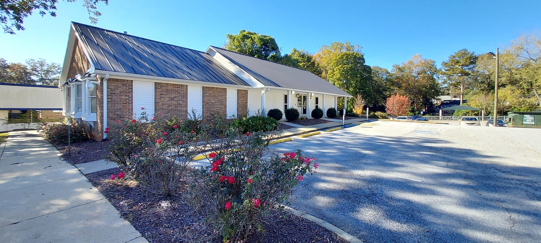
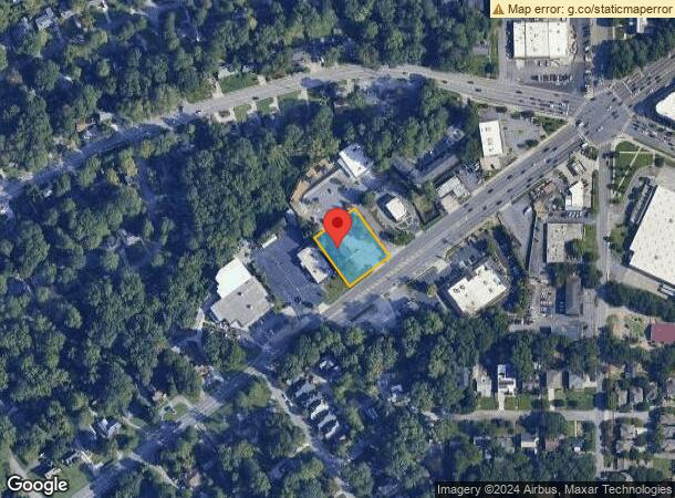
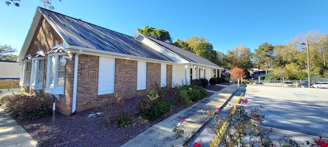
Property Record
1428 Scott Blvd, Decatur, GA 30030
Current Lease Availabilities
NEARBY LISTINGS FOR SALE OR LEASE
Property Detail
1428 Scott Blvd
18-050-08-040
Ken Long
Medicalbuilding
DeKalb
X
Georgia
13089C0066K
40
2023
0.60 AC
2023
Decatur
022303
Atlanta
3,689 SF
Atlanta-Sandy Springs-Roswell, GA
DEMOGRAPHICS near 1428 Scott Blvd
1 Mile
3 Mile
5 Mile
2024 Total Population
17,312
116,381
351,302
2029 Population
17,609
116,355
353,078
Pop Growth 2024-2029
+ 1.72%
(0.02%)
+ 0.51%
Average Age
40
39
38
2024 Total Households
8,087
48,959
153,813
HH Growth 2024-2029
+ 1.94%
(0.01%)
+ 0.66%
Median Household Inc
$90,289
$98,790
$85,357
Avg Household Size
2.00
2.20
2.20
2024 Avg HH Vehicles
1.00
2.00
2.00
Median Home Value
$451,713
$503,859
$456,882
Median Year Built
1979
1976
1978
Nearby Places
- Restaurants
- Banks
- Shops
- Fitness
- Groceries
PUBLIC TRANSPORTATION
COMMUTER RAIL
Atlanta (Crescent - Amtrak)
DRIVE
WALK
Distance
Atlanta (Crescent - Amtrak)
16 min
7.6 mi
AIRPORT
Hartsfield - Jackson Atlanta International
DRIVE
WALK
Distance
Hartsfield - Jackson Atlanta International
29 min
16.4 mi
Freight Ports
Georgia Ports - Savannah
DRIVE
WALK
Distance
Georgia Ports - Savannah
286 min
250.8 mi
Nearby Properties
Address
Land Use
TOTAL SIZE
Lot Size
Zoning
Address
Land Use
TOTAL SIZE
Lot Size
Zoning
2,612 SF
137.60 AC
X
Address
Land Use
TOTAL SIZE
Lot Size
Zoning
345,125 SF
7.73 AC
C1
Address
Land Use
TOTAL SIZE
Lot Size
Zoning
327,098 SF
4.92 AC
X
Address
Land Use
TOTAL SIZE
Lot Size
Zoning
589,761 SF
23.60 AC
RM-HD
Address
Land Use
TOTAL SIZE
Lot Size
Zoning
152,400 SF
3.27 AC
M
Address
Land Use
TOTAL SIZE
Lot Size
Zoning
360,321 SF
24.70 AC
RM85
Address
Land Use
TOTAL SIZE
Lot Size
Zoning
188,469 SF
4.06 AC
C-1
Address
Land Use
TOTAL SIZE
Lot Size
Zoning
357,531 SF
11.20 AC
RM75
Address
Land Use
TOTAL SIZE
Lot Size
Zoning
123,089 SF
5.01 AC
MU-4
Address
Land Use
TOTAL SIZE
Lot Size
Zoning
431,259 SF
48.80 AC
RM100
Address
Land Use
TOTAL SIZE
Lot Size
Zoning
393,333 SF
5.37 AC
X
Address
Land Use
TOTAL SIZE
Lot Size
Zoning
158,294 SF
2.80 AC
OI
Address
Land Use
TOTAL SIZE
Lot Size
Zoning
123,732 SF
0.50 AC
RM75
Address
Land Use
TOTAL SIZE
Lot Size
Zoning
244,293 SF
2.09 AC
C-2
Address
Land Use
TOTAL SIZE
Lot Size
Zoning
202,577 SF
3.10 AC
OI
Address
Land Use
TOTAL SIZE
Lot Size
Zoning
166,663 SF
8.60 AC
X
Address
Land Use
TOTAL SIZE
Lot Size
Zoning
104,501 SF
2.56 AC
X
Address
Land Use
TOTAL SIZE
Lot Size
Zoning
259,834 SF
3.56 AC
OI
Address
Land Use
TOTAL SIZE
Lot Size
Zoning
76,500 SF
2.84 AC
X
Address
Land Use
TOTAL SIZE
Lot Size
Zoning
174,052 SF
4.15 AC
MU-5
Address
Land Use
TOTAL SIZE
Lot Size
Zoning
198,241 SF
13.30 AC
RM75
Address
Land Use
TOTAL SIZE
Lot Size
Zoning
176,388 SF
8.90 AC
X
Address
Land Use
TOTAL SIZE
Lot Size
Zoning
104,218 SF
1.10 AC
C2
Address
Land Use
TOTAL SIZE
Lot Size
Zoning
286,700 SF
0.30 AC
G-C
Address
Land Use
TOTAL SIZE
Lot Size
Zoning
249,774 SF
15.90 AC
RM-HD
Address
Land Use
TOTAL SIZE
Lot Size
Zoning
181,951 SF
9.70 AC
RM-HD
Address
Land Use
TOTAL SIZE
Lot Size
Zoning
185,074 SF
10.50 AC
RM-HD
Address
Land Use
TOTAL SIZE
Lot Size
Zoning
93,584 SF
0.66 AC
X
Address
Land Use
TOTAL SIZE
Lot Size
Zoning
191,425 SF
2.40 AC
C2: GEN CO
Address
Land Use
TOTAL SIZE
Lot Size
Zoning
99,770 SF
1.94 AC
The World's #1 Commercial Real Estate Marketplace
Connect with us
© 2025 CoStar Group
The information above has been obtained from sources believed reliable. While we do not doubt its accuracy we have not verified it and make no guarantee, warranty or representation about it. It is your responsibility to independently confirm its accuracy and completeness. Any projections, opinions, assumptions, or estimates used are for example only and do not represent the current or future performance of the property. The value of this transaction to you depends on tax and other factors which should be evaluated by your tax, financial, and legal advisors. You and your advisors should conduct a careful, independent investigation of the property to determine to your satisfaction the suitability of the property for your needs.